Basic Concepts
The definitions are pretty simple. In Controlled Airspace, ATC provides
air traffic control services. In Uncontrolled Airspace, they don't. ATC
does still provide different types of services in uncontrolled airspace, if not
control services, though. All areas in Canada, including some airspace offshore,
are contained with an FIR, or Flight Information Region. Flight
information ranges from weather related data and pilot reports, to the one of
the most important issues called alerting service. In the real world, if
you don't depart within a certain amount of time from your proposed departure
time, land roughly when expected to (normally considered at an airport without
an ATC or FSS facility) or even report over a certain fix within a given amount
of time of the estimate for that fix, ATC will alert authorities with pertinent
information and they'll send someone out to look for you. This all relates to
flight information services, whether in controlled or uncontrolled airspace.
In uncontrolled airspace, ATC will not, and can not, take any action to separate
you from other aircraft. As part of flight information, ATC will, workload
permitting, provide you with traffic information. Much of the country's
uncontrolled airspace lies in low altitude or remote areas, making radar
coverage sparse. If radar coverage permits, ATC may radar identify you and
provide you with radar traffic information, such as "Traffic 12 o'clock 10
miles, opposite direction Navajo at 6,000 IFR". Otherwise, the traffic report
will be in relation to a fix on a chart, such as, "Traffic is a Navajo, opposite
direction on RR22 estimated over Charlo NDB at 1347z, 6,000 IFR". It's then your
job to determine what impact this traffic may have on your flight, if any at
all.
Classes of Airspace
How do you know if you're in controlled or uncontrolled airspace? You have to
know what Class of airspace you're in. A few years ago, the
classifications of airspace changed to more closely match ICAO's standards in
use elsewhere in the world. We now have 7 classifications, lettered A-G. Where
they are, what you're allowed to do in each, and what ATC services can be
expected in each, vary. A little bit of basics here is that, in Canada, High
Level Airspace is that airspace from 18,000 feet ASL (considered FL180) and
above, and Low Level Airspace is everything below that. Note that for ATC, many
FIRs are split "High" and "Low", but this has no bearing on, and no relation to,
the book definitions of High and Low Level airspaces. For example, Moncton and
Gander (among others) are split high-low with high level's area beginning at
FL290. Low level, therefore, is below FL290, and this includes some High Level
airspace, between FL180 and up to, but not including, FL290. The following
definitions of the classes are taken out of the AIP Canada, RAC 2.8,
Classification of Airspaces. All of this information applies to Canadian
Airspace specifically, so if you're outside of Canada, the information below may
not be correct.
Class A Airspace
Class A airspace is designated where it is desirable to exclude VFR completely,
and all operations, regardless of weather conditions, are to be IFR.
Transponders must be on board all aircraft, and they must include mode C for
altitude encoding. Class A airspace includes all controlled High Level Airspace
up to and including FL600. Note that there is some High Level Airspace in the
Northern and Arctic Control Areas that is not controlled. Also, all the North
Atlantic Airspace is Class A airspace at and above FL55 (approx. 5,500 feet) up
to and including FL600.
Class B Airspace
Airspace where IFR control service is desired, and a need to control VFR
aircraft exists, is designated Class B. All Low Level controlled airspace above
12,500 (at or above the Minimum Enroute Altitude for an airway) is classified as
Class B. Since it's Low Level Airspace, it goes up to, but doesn't include,
18,000 (FL180). Control Zones around airports and Terminal Control Areas may
also be designated as Class B. VFR aircraft must talk to ATC and obtain
clearance from ATC prior to entering Class B airspace. A listening watch must be
maintained on the appropriate frequency, and the aircraft must remain in Visual
Meteorological Conditions (VMC). If VMC cannot be maintained, the VFR aircraft
must request an amended clearance to allow the flight to continue VMC. If this
is not practicable, leave Class B airspace via the shortest, safest route, by
either descending out, or leaving laterally if practicable, and report actions
taken to ATC as soon as possible.
Class C Airspace
Both IFR and VFR flight is permitted in Class C airspace. As with Class A and B,
all IFR aircraft are provided with control service, and therefore separation
from other aircraft at all times. VFR flights must request and receive a
clearance to operate in Class C airspace. As necessary to resolve conflicts
between IFR and VFR aircraft, ATC has authority to direct VFR aircraft and
provide IFR separation minima between IFR and VFR aircraft. For VFR vs. VFR,
aircraft are provided with traffic information, and "conflict resolution" will
be provided upon request. This means that aircraft will be given instructions to
avoid each other, rather than a hard and fast separation standard.
Terminal Control Areas and associated Control Zones at airports may be
classified as Class C airspace, and these areas revert to Class E airspace when
the associated ATC units are not in operation. All flights must be equipped with
Mode C transponders in Class C airspace.
Class D Airspace
As with Class C, both IFR and VFR are permitted in Class D airspace. VFR flights
wishing to operate with Class D airspace need only establish two-way
communication with the appropriate ATC unit to enter, so a clearance is not
required. IFR aircraft are provided with separation between other IFR aircraft.
Equipment and workload permitting, conflict resolution will be provided between
VFR and IFR aircraft, and upon request only between VFR aircraft and other VFR
aircraft.
Terminal Control Areas and associated Control Zones may be designated as Class
D. These airspaces revert to Class E airspace when the associated ATC unit is
not in operation. Many Class D areas are designated as Transponder Airspace. If
so, a Mode C transponder is required for operation within unless otherwise
authorized by ATC.
Class E Airspace
Now the services start to thin out a bit. Much of the controlled airspace in
Canada is Class E. This includes all of the controlled airspace that is not
already designated Class A, B, C or D airspace. Sounds vague, right? All Low
Level airways, control area extensions, Control Zones around uncontrolled
airports (yes, this happens in many areas) and other areas are designated Class
E. IFR flights still require a clearance to operate within Class E and they are
provided with separation only from other IFR aircraft, while VFR flights need
nothing more than VMC. No communication is required with ATC, nor is a
clearance. VFR aircraft are not entitled to ATC separation in Class E airspace,
though traffic information can be provided, workload and equipment permitting.
How could you have a control zone without a control tower at an airport? They
have established these to ensure controlled airspace exists right to the ground.
The two effects this has, even without a tower, is to allow ATC the authority to
apply IFR separation right to the ground at such an airport, and to raise the
weather minima around such an airport for operating VFR to increase the safety
margin in a mix of IFR and VFR traffic. As mentioned above, Class C and D
airspace reverts to this class of airspace when the associated ATC unit is not
in operation. This includes terminal control areas and control zones that
normally have towers in operation.
Class F Airspace
Class F airspace is designated to confine activities that are potentially
hazardous to aircraft not involved in the activity. Hence, Class F is also
called "Special Use Airspace". There are two categories, Advisory, and
Restricted. Class F airspace assumes the rules of the airspace surrounding
it when it becomes in active.
The airspace within an Advisory area may be controlled or uncontrolled,
or even a combination. Typically Class F Advisory airspace is designated where
activities such as gliding, parachuting, high traffic training areas, and
military operations take place and it would be of benefit to aircraft operators
to be aware that such activities are taking place there. While there are no
specific restrictions, VFR aircraft should avoid flight in these areas if
practicable. IFR aircraft will not be permitted to enter Class F Advisory
airspace unless the pilot has stated he has obtained permission to enter the
area, he is operating on an Altitude Reservation, or he has been cleared for a
Contact or Visual Approach. Otherwise, he'll be kept 500 feet clear vertically,
unless wake turbulence separation is needed (at which time it becomes 1,000
feet), and he will not be permitted to penetrate the lateral boundaries. Pilots
entering an Advisory area should monitor the published frequency, if one is
designated, to gain a better knowledge of activities within the area. 126.7 is
used if none is designated.
Restricted areas are a little more dangerous. These are generally
established when safety or security is an issue, such as when military
operations are heavier, including such things as live firing or high speed
training, or around high importance locations. One example of the latter occurs
with the G8 Summits involving heads of states. Other aircraft are prohibited
from entering these areas. While the agency who controls the area may
occasionally permit ATC to clear aircraft through a Class F Restricted area,
normally, IFR aircraft are kept clear of these areas by the appropriate vertical
minimum (1,000 feet below FL290, and 2,000 feet above FL290, even for RVSM
aircraft) or by an appropriate lateral minimum. Where radar separation can be
used, this is expected.
Additionally, airspace may be classed as Class F Restricted if air traffic would
benefit from certain restrictions. Reducing airport operations to only traffic
departing and arriving, avoiding the congestion of VFR overflights is one
example of such a practice, though there aren't many of these in Canada.
Class F airspace is designated in the following fashion:
For example, the military training area for CFB Gagetown in New Brunswick is
CYR 724. Also, the Advisory area used for soaring out of Stanley, Nova Scotia,
is CYA 753 (S).
Class G Airspace
Uncontrolled airspace. That's about it, in general terms. All other airspace in
Canada, whether high or low level, not designated as anything else, is
considered Class G. Both IFR and VFR flights may operate without a clearance,
and neither are entitled to ATC separation. Both can get flight information from
ATC, equipment and workload permitting, but essentially, you're on your own.
Weather minima for flying VFR are lower in uncontrolled airspace, reducing the
safety margin of IFR operations down low, such as on approach. This is the
reason for establishing controlled airspace in the form of transition areas
close to airports. The higher weather minima force a better chance of "see and
be seen" for both aircraft.
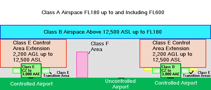
Normal Structures of Airspace
The major airports in Canada are surrounded by controlled airspace, mostly Class
D control zones. These control zones are built from the surface up to a
specified altitude, typically around 3,000 feet above aerodrome elevation (AAE).
These can be other classifications as well. Outside of most control zones are
transition areas, typically based at 700 feet AGL. Then there are control area
extensions outside of these areas, and they are normally based at 2,200 AGL.
Depending on the area involved, many areas go to uncontrolled airspace between
airways, so the base of controlled airspace might then become "above 12,500 ASL",
meaning that 12,500 itself is uncontrolled. Above 12,500, if it's controlled
airspace, it becomes Class B airspace. Some outlying areas actually have the
base of controlled airspace up at 18,000 feet ASL, or FL180 as we know it.
Whatever the base, controlled airspace is designated where it is determined that
safety will benefit from the establishment of such additional structure. As
alluded to earlier, controlled airspace increases the weather minima for VFR
flight, in theory giving pilots of both IFR and VFR aircraft a better chance of
seeing each other. The control area extensions and, in particular, the
transition areas established near airports are place there to allow IFR aircraft
to conduct IFR approaches with that very restriction: to force VFR
operations out in lower weather to increase the margin of safety for IFR
flights. Commonly used tracks, mostly based on NAVAIDs, are typically located
within controlled airspace as well, since historically they are frequented by
IFR aircraft. Outside of airspace commonly used for IFR flights, you'll often
find uncontrolled, or Class G, airspace. Given the way the airspace is actually
designated, the common description is often considered to be an upside-down
wedding cake. Have a look at the following diagram.
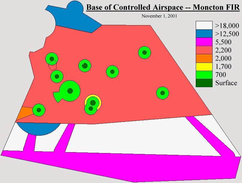
To give an idea of what an FIR looks like when the base of controlled airspace
is plotted out, I've included the following diagram to demonstrate.